Floods in Bandar Seri Jempol
Nov 23, 2017 08:53
Sep 27, 2026 15:11
Location
Coordinate:
2.894937, 102.406409
Administrative:
Negeri Sembilan, Malaysia
Affected Area:
Negeri Sembilan
Hazard
Main : Flood- Inundated Area (km) = fill value here
- Maximum Flood Depth (cm) = fill value here
Description
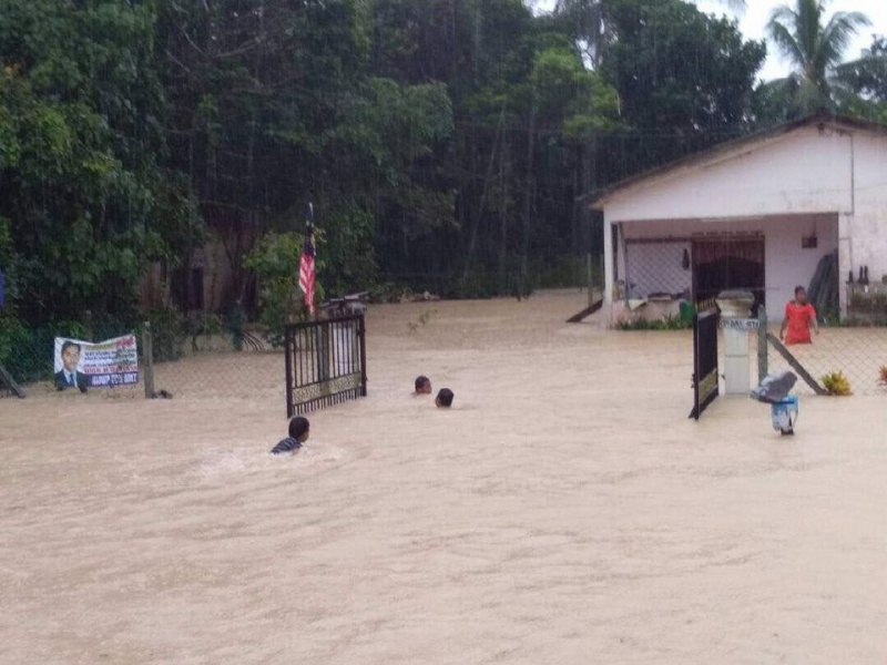
BANDAR SERI JEMPOL: Several areas in this area, hit by flash floods due to continuous rain since early this morning. Water spots include Kampung Serampang Indah, Kampung Gajah Mati, Taman Anggerik, Batu Kikir and Jalan Taman Mahsan. Head of Kampung Serampang Indah, Amran Mohamad, said that heavy rain from 6am this morning caused nine houses in the village to be flooded. He said that until 11am, the water reached almost one meter, but the situation was still under control as only three homes were occupied. "Residents in the three houses are reluctant to move, but all the other residents are in a state of alert and ready to move if the water is still rising. "At the same time, access to the village is also flooded and light traffic can not be reached," he said when met here, today. Meanwhile, the Public Works Department (JKR) closes Kuala Pilah-Simpang Pertang Road and Taman Anggerik in Batu Kikir as a result of the flood. Jempol JKR District Engineer Rosdi Abu Bakar said the road was closed for safety reasons due to heavy traffic. He said users wanting to Simpang Pertang can use the Seri Jempol-Serting Road or Black Water Way via Bahau.
Impact Statistic
0
Dead
0
Missing
0
Injured
45
Affected Person
0
Displaced
External Video
News
Human SADDD
- Dead -
- Missing -
- Injured -
- Affected Person 45
- Affected Family 9
- Internaly Displaced People -
- Refugees 0
- Evacuation Center (in Country) -
- Evacuation Center (out Of Country) 0
House
- Affected Houses 0
- Damage Partial 0
- Totally Damage -
Infrastructure
- Bridges 0
- Number of Roads 0
- Road Distance (km) 0.00
Public
- Schools -
- Health -
- Government Office / Public Facilities 0
- Settlements 0
- Worship Places 0
- Others 0
General
Cost
- Local Currency 0.00
- Cost of Damages 0.00
- Cost of Damages (USD) -
- Cost of Assistance 0.00
- Cost of Assistance (USD) -
Agricultural
- Rice Field 0.00
- Other Crops 0.00
- Fish Ponds 0
- Cattle 0
- Poultries 0
- Livestock 0
Relevant Disasters
The ASEAN Disaster Information Network (ADINet) is a repository of information concerning hazards and disasters that have happened in the region. The platform is open for public, which means that the public can submit information about any hazard and disaster to the AHA Centre. Thereafter, the AHA Centre will verify and validate any submitted information to ensure the accuracy of the data inputs. The AHA Centre can also add new information when relevant and as necessary. ADINet has been recording disaster information in the region since the AHA Centre was operational in 2012.

Supported by :